Siesta Key Map: 3 Beaches, 2 Bridges and Where Everything Is
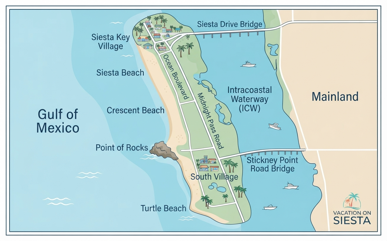
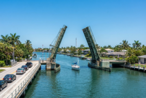
A Siesta Key map shows an 8 mile, crescent shaped barrier island in the Gulf of Mexico, just west of Sarasota in Sarasota County, Florida, with every public beach on its west side facing the Gulf. Two drawbridges over the Intracoastal Waterway connect it to the mainland: the Siesta Drive bridge on the north end and the Stickney Point Road bridge on the south end, according to the Siesta Key Chamber of Commerce. The whole island shares one zip code, 34242.
This guide walks the island from north to south so you can picture where the villages, beaches, beach accesses, and main roads sit before you arrive.
Where Is Siesta Key on a Map of Florida?
Siesta Key sits on the Gulf Coast of Southwest Florida, directly off the city of Sarasota. Visit Florida places it about 60 miles south of Tampa and about 10 miles from Sarasota, a 15 to 20 minute drive. The Gulf of Mexico forms the island’s entire western shoreline, and the bays and the Intracoastal Waterway separate its eastern shore from the mainland.
Because it is a barrier island, you can only drive onto Siesta Key across one of its two bridges. Siesta Drive brings you onto the north end near Siesta Key Village, and Stickney Point Road brings you onto the south half of the island at South Village.
Siesta Key at a Glance
| Feature | Detail |
|---|---|
| Island length | About 8 miles (Siesta Key Chamber) |
| Land area | 2.34 square miles for the Siesta Key census designated place (U.S. Census Bureau) |
| Distance from Sarasota | About 10 miles, a 15 to 20 minute drive (Visit Florida) |
| County | Sarasota County |
| Zip code | 34242 |
| Bridges | Siesta Drive (north) and Stickney Point Road (south) |
| Main roads | Ocean Boulevard, Beach Road, Midnight Pass Road |
| Main public beaches | Siesta Beach, Crescent Beach, Turtle Beach |
What Does the Siesta Key Map Look Like from North to South?
Think of Siesta Key as one long strip with the Gulf on your right as you drive south. Visit Florida lists three main beach destinations plus a string of numbered neighborhood beach accesses, running in this order from north to south: Siesta Beach, Crescent Beach, Point of Rocks, and Turtle Beach.
Siesta Key Village (North End)
Siesta Key Village is centered on the intersection of Ocean Boulevard and Canal Road, according to the Siesta Key Chamber. It holds beach retail, restaurants, and a grocery store, with free street parking on Ocean Boulevard plus free and paid lots. The Siesta Key Visitor Center is here too, at 5223 Avenida Navarra. Our Siesta Key shopping guide covers the Village stores in detail.
Siesta Beach (Main Public Beach)
Siesta Beach is the island’s main public beach park, at 948 Beach Road, Sarasota, FL 34242. Visit Sarasota lists lifeguards, a pavilion, a playground, volleyball courts, food concessions, restrooms, beach wheelchairs, and parking at the park. It sits on the Gulf just south of the Village along Beach Road.
Crescent Beach and Point of Rocks
Crescent Beach runs south from Siesta Beach along the Gulf and is reached through numbered public beach accesses rather than one large park. Visit Sarasota says Point of Rocks lies just beyond Crescent Beach, a little further walk south, and describes it as a popular snorkeling and diving spot. Point of Rocks is on the Gulf side, like every other beach on the island.
Stickney Point and South Village
South Village sits immediately west of the south bridge, at the intersection of Stickney Point Road and Midnight Pass Road, per the Chamber. It has a grocery store, boutiques, beach equipment rentals, fishing charters, and a marina. The Chamber notes it sits near Crescent Beach Access 12.
Turtle Beach and the South End
Turtle Beach Park sits near the south end of the island at 8918 Midnight Pass Road. Sarasota County describes it as a site with a mangrove lagoon and beautiful beaches. Visit Florida calls it a quieter, more natural experience than Siesta Beach, and it is the southern end point of the island trolley route.
For a side by side comparison of what each beach is like, read our guide to the best beaches in Siesta Key. To find the best spot for golden hour, see our Siesta Key sunset viewing guide.
Where Are the Public Beach Accesses on a Siesta Beach Map?
Beyond the three beach parks, Sarasota County maintains numbered public beach accesses along Beach Road and Midnight Pass Road. The official 2026 Siesta Key Chamber map marks 12 numbered accesses along the shoreline. Some, such as Beach Access 3 at 100 Beach Road, are pedestrian only with no parking, while Beach Access 12 at 6490 Midnight Pass Road is open 6 a.m. to 10 p.m. daily.
Parking rules vary by access, so check the county listing before you go. Our Siesta Key public beach guide covers access points and parking in more detail. Our rentals sit near Siesta Key Village, Southside Village, Beach Access 5 and 11, and Stickney Point, close to several of these accesses.
How Do You Get Around the Siesta Key Map?
The free open air trolley is the easiest way to move between the villages and beaches. The Siesta Key Chamber says the trolley, part of Sarasota County’s Breeze transit system, follows Ocean Boulevard to Beach Road and down Midnight Pass Road, running daily from 8 a.m. to 10 p.m. Read our Siesta Key trolley guide for stops and tips.
Golf carts are another popular way to cover short distances on the island. Our Siesta Key golf cart rental guide explains where to rent and where you can legally drive one.
How Do You Get to Siesta Key?
Most travelers fly into a nearby Florida airport, drive to Sarasota, and cross onto the island over the Siesta Drive or Stickney Point Road bridge. Our guide on how to get to Siesta Key Beach from the airport compares airports, drive times, and ground transportation.
Once you know the lay of the land, choose a home base close to the beach and village you plan to visit most. Browse our Siesta Key vacation home rentals or contact us to start planning your stay, or call us at 941 422 2716.
Frequently Asked Questions About the Siesta Key Map
Is Siesta Key in Sarasota?
Siesta Key is a barrier island in Sarasota County, just west of the city of Sarasota. Sarasota County park addresses on the island use Sarasota, FL 34242 as the mailing address.
What is the Siesta Key zip code?
The Siesta Key zip code is 34242. Siesta Beach, Turtle Beach Park, and the Siesta Key Visitor Center all use this zip code.
How many beaches are on Siesta Key?
Siesta Key has three main public beaches: Siesta Beach, Crescent Beach, and Turtle Beach. Point of Rocks sits just south of Crescent Beach, and numbered public beach accesses line the shore between them.
Which side of Siesta Key are the beaches on?
All of the public beaches are on the west side of Siesta Key, facing the Gulf of Mexico. From north to south they run Siesta Beach, Crescent Beach, Point of Rocks, and Turtle Beach.
How do you get onto Siesta Key?
You drive onto Siesta Key across one of two drawbridges over the Intracoastal Waterway: the Siesta Drive bridge on the north end or the Stickney Point Road bridge on the south end.